


Le télégraphe Ceyreste

Eric Go
User
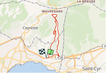

Length
13 km

Max alt
465 m

Uphill gradient
450 m
Km-Effort
19 km

Min alt
59 m

Downhill gradient
449 m
Boucle
Yes
Creation date :
2025-06-07 08:26:07.0
Updated on :
2025-06-16 07:15:51.204

FREE GPS app for hiking
 SityTrail
IGN / Geographical institutes
SityTrail Plus
The world is yours!
About
Trail of 13 km to be discovered at Provence-Alpes-Côte d'Azur, Bouches-du-Rhône, La Ciotat. This trail is proposed by Eric Go.
Positioning
Country:
France
Region :
Provence-Alpes-Côte d'Azur
Department/Province :
Bouches-du-Rhône
Municipality :
La Ciotat
Location:
Unknown
Start:(Dec)
Start:(UTM)
715967 ; 4785557 (31T) N.
Comments